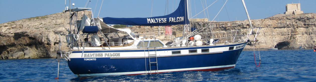
November 6th, 2007
NY to Bermuda:
Wow, finally we left Great Kills Harbor at noon on November 6th, 2007, two and half weeks after arriving here.
We enjoyed our stay here, for $5.00/day we had access to the facilities of the Great Kills Yacht Club including showers dingy dock the bar $1/beer etc… and when we wanted to tie up at the slip it was $1.00 per foot including water and electricity for a slip twice as wide and long as the one we had at Port Credit. From this base we made regular visits to NY City by bus for $5.00 each way, this trip usually took one and half hours to get to uptown NY City at 57th St and 6th Ave.
The last front had just passed over us during the early morning hours and now the wind has shifted from the NW at around 15 knots. The sky was grey and some drizzle still lingered on but we could see a break in the sky behind us towards the western sky.
We motor-sailed out towards the top end of Sandy Hook peninsula and then headed SE towards Bermuda. We did not have much luck talking with herb the weatherman in Canada for the last three days so we gathered as much information as we could from the Internet and the VHF weather service, all looked to be good.
We hoisted the staysail and with one reef in the main we needed some Genoa added to the mix to get some more speed as the wind was at 10 to 15 knots but by 11:30 pm the Genoa had to be rolled in and the staysail pulled down as the winds had picked up to 25 knots with gusts to 30 knots. By 2:00 am the main had another reef put in it as the wind increased to 35 knots with gusts to 40 knots and seas had built up to about 12 to 15 ft. It became very uncomfortable for both of us, I got seasick and Lillian wasn’t feeling that good either. The skies did clear up the temp was around the freezing mark or slightly above, the spray was everywhere. Sleep was very difficult on this first night but we managed to stay on watch together at times just to comfort each other.
The next day the winds diminished slightly to about 25 knots but the seas were still very confused and big. Eating was not on our mind.
In the afternoon we tried to talk to Herb the weatherman but propagation was non-existing and we could hear some other boats were having the same problem as we could hear them trying to make contact with him to no avail.
The next day was more of the same with overcast skies and uncomfortable seas. In the afternoon we managed to talk to Herb, but the news he gave us was not good as he explained the movement of a low-pressure system coming off Cape Hatteras and that for the next two days we would have 35 knot winds first from the NE then clocking to the SE for the second and third day. I asked if it would be advisable to head west toward Norfolk and he suggested that I should do just that since I had not yet hit the Gulf Stream.
At the time we were 189 miles east of Norfolk Virginia, we altered course for Norfolk. We had a great sail towards Virginia as by now the seas had calmed down somewhat; we even send the fishing lure over but no catch. We arrived early Friday morning and got onto the ICW at around 11:00 am and stopped at Chesapeake City and are sitting at the free town dock just past Big Bridge.
We have not decided what we are going to do, we may carry on down the ICW to Florida and then the Bahamas or, if we get a good weather window we may just head out of Beaufort NC to Bermuda or straight to ST Martin.
So, For now, we are going to enjoy the sites along the ICW and then we see what happens. We do not have any cruising guides for the ICW and I didn’t even know we had to go through one lock, which we did yesterday.
Lookout for our next instalment to find out what we decided to do
 |
| The Beaufort waterfront |
November 16, 2007
The North ICW: Norfolk Virginia to Beaufort North Carolina
Okay so we are on the ICW, not by choice but more by circumstance, we have not yet made up our mind if we are going to head further south on this canal or head to Bermuda or St Martin from Beaufort, time will tell but I am still leaning towards the latter plan whereas Lillian would like to actually go to Charleston, St Augustine etc….
But for now, we are trying to enjoy the north part of the ICW.
Since getting in here we have had our bad share of weather, waiting it out before going out on the sounds, I don’t know why they are called sounds everything around here is one big swamp, the sound to me is like a treeless swamp. But anyway we are doing the best, we stopped at a marina in Coinjock for $1.75/foot optional 30 amp service for $7.00/day, here we had a great seafood lunch, everything around here is about crabs, fish and peanuts.
Before that, we stayed for a couple of days at Chesapeake City dock for free, a great place to provision. The day after we dropped anchor at position: 35° 40.552’N x 76° 03.614 W, between Newport News Pt. and Bear Pt. in 7 feet of water and watched one of the most beautiful sunsets with and all the birds around us, in perfectly calm waters, I would put this up with one of the most memorable evenings, when you get a sunset like this one it has to be up there.
Our next stop was another anchorage at position 35° 12.580’ N x 76° 35.456’ W the bay south of Gale Creek. South of us is the infamous Pamlico Sound the largest body of water in North Carolina, of which Cape Hatteras is part of. Here we had to wait out for another day as a front was passing the next day with gale force winds, and you don’t want to have gale force winds and rain while moving on the Pamlico Sound.
We left early November 16th for Beaufort, the winds where from the NW at 25knots so it would be a beam reach on the sound for 3 hrs. till we get into sheltered waters. Flying under full Genoa and the engine we made very good time to the sheltered water then bump, the boat went up and then down again looked at the chart on the computer and we were in the wrong place missing one of the red markers. Thank God it’s all mud around here so no damage was done and I got the boat of the hill below. Carried on down the ICW and made it to picturesque Beaufort by 1400 hrs. here we picked up a mooring.
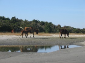 |
| Wild horses on Carrot Island |